Start the conversation
Contact us today to see how you could benefit from our services, technology and marine expertise

Our technology. Your way
When it comes to ocean science, NOC Innovations leads the way.
And having designed, built and implemented industry-leading technology for over 60 years, we recognise our creations can reach far beyond our own walls.
That’s why our clients are increasingly opting for technology transfer collaborations with us such as licensing.
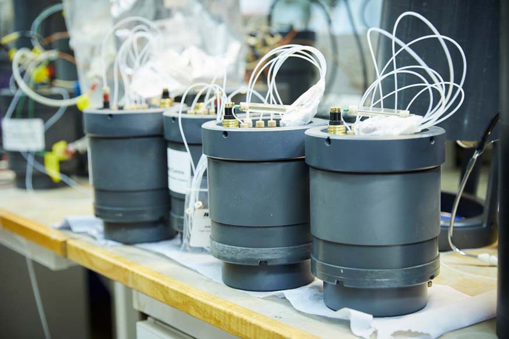
A new novel anchoring system has been designed for repeated anchoring of AUVs to the seabed, conserving power, reducing costs, and extending mission duration.
Users of Autonomous Underwater Vehicles (AUVs) often face limitations when operating vehicles in the field, with detrimental effects on mission planning, power consumption, scalability, vehicle safety, cost, and more. A new technological development has been created which enhances these capabilities and mitigates risks around deployment.
Without the ability to anchor an AUV to the seabed, the scope and success of deployment can often depend upon favourable weather conditions. This – coupled with a dependency on battery power – creates substantial limitations on effective planning and execution. The lack of an innovative, risk-free anchoring solution for AUVs also increases the chance of an AUV being trapped on the seabed, with significant losses of cost and data collection at stake, as well as environmental pollution.
It was essential for seabed anchoring to be enabled and designed in a way for AUVs to mitigate these issues.
Developed by the National Oceanography Centre (NOC), the Anchor System represents a significant milestone in underwater technology and research. This innovation allows for multiple anchoring events of the same vessel – a solution for long-duration research and survey missions requiring underwater vehicles.
Repeated anchoring to the seafloor enables these vehicles to hibernate between work intervals and during unfavourable weather conditions. This technology can also lead to cost reduction by extending on-site mission durations and conserving battery power, as well as lowering the risk of an AUV and its collected data going missing.
How it works: the anchor compartment of the AUV is flooded, making the vessel negatively buoyant so that it sinks. Once the anchor hits the seabed, the AUV returns to positive buoyancy and rides clear, operating in low power mode to either hibernate or carry out passive monitoring as required. Once the AUV is due to continue its mission, the anchor tether is released.
The Anchor System has a wide range of useful applications, including but not limited to: oceanographic research, environmental monitoring and surveying, offshore energy exploration, pipeline inspection, and underwater archaeology. This is applicable to both optimising operational capacity in active missions, where it would be beneficial to have the ability to anchor to the seabed for battery saving between tasks, and for static missions, where the AUV stays in one set location and monitors its immediate environment (such as listening to marine life). An anchored AUV is virtually silent compared with the acoustic noise from operating thrusters, and therefore mitigates disturbance and disruptions around it, leading to more accurate readings.
This technology is now available to license through our partner, Ploughshare. Contact us to find out more about this technology and discuss the licensing opportunities available.
Our radar imaging capabilities provide greatly enhanced and accurate situational awareness for vessels
NOC Innovations, in collaboration with Ploughshare Innovations, is introducing a groundbreaking radar imaging technology – High-Resolution Radar Image Mosaicking. This technique leverages commercial-off-the-shelf (COTS) radar systems and a unique ‘patch testing’ method for a radar installation to produce stabilised imagery for marine remote sensing, particularly effective in coastal and inshore waters. This advancement promises a phase-change in radar remote sensing capabilities, with potential applications in various sectors.
There is currently a crucial gap in marine radar capabilities, particularly when it comes to creating accurate depictions of landmass and surface objects with a small radar cross section such as ARGO floats, micro-scale submersibles, surface debris or person overboard. In addition, small vessels are not traditionally exploited for marine remote sensing due to large ‘standard’ radar equipment being unsuitable.
Developed by the National Oceanography Centre (NOC), the High-Resolution Radar Image Mosaicking technique integrates with existing radar equipment, offers accurate depictions of landmass and surface objects over time from a moving vessel. This technology represents a significant departure from traditional radar imaging methods, catering specifically to small work class vessels and uncrewed surface vessels (USVs), thus expanding the horizon of radar remote sensing to new low-cost, low-power COTS radar hardware.
This technology has a wide range of applications including commercial radar system operators, manufacturers and developers, with additional interest from end users across various sectors including defence and scientific research.
This technology is now available to license through our partner, Ploughshare. Contact us via techtransfer@noc.ac.uk to find out more about this technology and discuss the licensing opportunities available.

Through multiple models, we share our technology with our portfolio of partners, providing them with a competitive advantage in their industry.
But while our technology captures the data we need from the most challenging of marine environments, its potential outside of ocean science is huge.
Today, our technology is used in sectors such as defence, water treatment, coastal protection and battery manufacturing, to name a handful.
Huw Gullick
Associate Director NOC Innovations
And because we’re an ocean science centre and not a product manufacturer, our resources are dedicated to research and development. This means we’re constantly designing, testing and adopting new and disruptive technologies.
We’re set up to transform ideas into concepts, concepts into prototypes, and prototypes into field-proven equipment.
We also have the expertise to steer our creations through the Technology Readiness Levels, including lab- and field-based testing.
Our partners engage with us at all tech development stages. Many work with us on an ongoing basis, and recognise the value of utilising a specialist research and development partner without having to actually invest in the capabilities themselves.
This marine technology transfer model helps them keep their operational costs low while giving them access to industry expertise far beyond what they could or may wish to develop on site.
Our technology licensing
Our core areas of development are:
- Sub-surface autonomous vessels and robotics
- Autonomous communications
- Autonomous command and control systems
- Tidal data, software and analytics
- Energy management systems and depth (up to 6,500m)
- Chemical sensors
- Coastal monitoring and protection instruments and systems
- Radar technology
- Remote operating control centres
- Oceanographic instruments and equipment
When you lease our tech, you’ll have the legal rights to install it, use it and profit from it.
But it goes beyond that. You’ll also be privy to the latest scientific insights, and gain access to the most up-to-date versions of the world’s leading marine research tools.
By leasing our world-class technology, you can gain accurate data on site and download it instantly.
Huw Gullick
Associate Director NOC Innovations
designing and building technology